


Disaster Alert

คำอธิบายของDisaster Alert
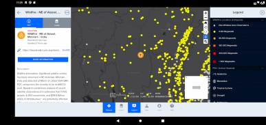
Disaster Alert เป็นแอพมือถือฟรีสำหรับการใช้งานสาธารณะที่ให้ชุมชนทั่วโลกได้รับการแจ้งเตือนอันตรายที่สำคัญและข้อมูลที่จำเป็นในการรักษาความปลอดภัยทุกที่ในโลก Disaster Alert™️ สร้างขึ้นบนแพลตฟอร์ม DisasterAWARE®️ ของ PDC นำเสนอข้อมูลอัปเดตเกือบเรียลไทม์เกี่ยวกับภัยธรรมชาติ 18 ชนิดที่แตกต่างกันทั่วโลก
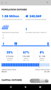
ด้วย Disaster Alert คุณสามารถปรับแต่งการแจ้งเตือนล่วงหน้า ดูรายงานผลกระทบโดยประมาณ และเข้าถึงข้อมูลอันตรายจำลองที่เป็นภาพ กระแสข้อมูลใหม่อย่างต่อเนื่องของ Disaster Alert ถูกสร้างขึ้นโดยอัตโนมัติจากแหล่งข้อมูลที่น่าเชื่อถือและได้รับการยืนยันทางวิทยาศาสตร์มากที่สุด เมื่อไม่มีแหล่งข้อมูลที่เป็นทางการ การแจ้งเตือนจะได้รับการอัปเดตด้วยตนเองโดย Pacific Disaster Center โดยแสดงช่วงเวลาเพียงเล็กน้อยระหว่างเวลาของเหตุการณ์และความพร้อมใช้งานของข้อมูลในระบบ
การอัปเดตอันตรายที่มาพร้อมกับ Disaster Alert จะรวมเฉพาะอันตรายที่ทำงานอยู่เท่านั้น “อันตรายจากการเคลื่อนไหว” เป็นส่วนหนึ่งของการรวบรวมเหตุการณ์ล่าสุดที่ได้รับการกำหนดให้เป็นอันตรายต่อผู้คน ทรัพย์สิน หรือทรัพย์สินโดย PDC
รวมประเภทอันตราย
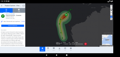
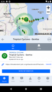
*ประมวลผลโดยอัตโนมัติในเวลาใกล้เคียงเรียลไทม์: เฮอริเคน (พายุไซโคลนเขตร้อน / ไต้ฝุ่น) แผ่นดินไหว สึนามิ ภูเขาไฟ น้ำท่วม ไฟป่า พายุทอร์นาโดในสหรัฐฯ และพายุฤดูหนาว
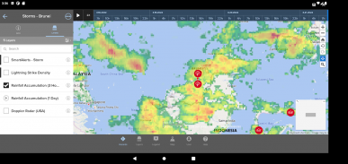
*ดำเนินการด้วยตนเอง: ภัยทางทะเล พายุ ภัยแล้ง และเหตุการณ์ที่มนุษย์สร้างขึ้น คำแนะนำเรื่องคลื่นสูง ลมแรง และน้ำท่วมฉับพลันมีเฉพาะในฮาวายเท่านั้น
ใหม่ในเวอร์ชัน 7.5.4
*ธีมเริ่มต้น: ธีม PDC ถูกนำไปใช้เป็นธีมเริ่มต้นในการแจ้งเตือนภัยพิบัติ ธีม PDC รวมเอาการสร้างแบรนด์ สี และการยึดถือสัญลักษณ์ของ DisasterAWARE เข้าด้วยกัน อาจใช้ธีมต่างๆ จากเมนู User Preferences
*การเข้าสู่ระบบและการลงทะเบียนหลายภาษา: ผู้ใช้ Disaster Alert จะสามารถเข้าสู่ระบบและลงทะเบียนในภาษาต่างๆ ที่รองรับนอกเหนือจากภาษาอังกฤษ มีตัวเลือกแบบหล่นลงที่ด้านบนของแบบฟอร์มที่อนุญาตให้ผู้ใช้เปลี่ยนตัวเลือกภาษา
*การเริ่มต้นใช้งาน: เราได้เปิดตัวฟีเจอร์การตั้งค่าแอปสำหรับผู้ใช้ครั้งแรกแบบใหม่ การแจ้งเตือนภัยพิบัติ เพื่อให้สามารถปรับแต่งตำแหน่งการแจ้งเตือนและความรุนแรงของอันตรายได้ หน้าจอนี้จะแสดงสำหรับผู้ใช้ทั้งหมดเมื่ออัปเดตจากเวอร์ชันก่อนหน้าเป็น 7.5.4 รวมถึงการติดตั้งใหม่ ผู้ใช้จะได้รับตัวเลือกในการลงชื่อเข้าใช้ เข้าสู่ระบบ หรือข้ามไปยังการแจ้งเตือนภัยพิบัติโดยตรงในฐานะแขกโดยไม่ต้องมีบัญชี การตั้งค่าการแจ้งเตือนสามารถปรับแต่งได้โดยผู้ใช้ที่ลงทะเบียนเท่านั้น
*อีเมลลงทะเบียนผู้ใช้: ขณะนี้ Disaster Alert รองรับรูปแบบอีเมลลงทะเบียนเพิ่มเติมสำหรับรูปแบบอีเมล plusaddressed (หรือที่เรียกว่า sub-addressed) สำหรับฟอร์มการลงทะเบียนผู้ใช้ใหม่
คุณสมบัติหลักอื่น ๆ
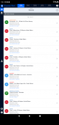
*การแจ้งเตือนที่ปรับแต่งได้ตามพื้นที่ทางภูมิศาสตร์ที่คุณสนใจและความรุนแรงของอันตราย
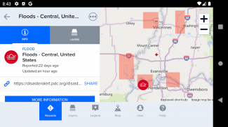
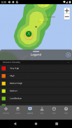
*เมื่อเปิดใช้งานคำแนะนำแผนที่โดยการเลือกอันตรายบนแผนที่ ผู้ใช้สามารถรับข้อมูลผลกระทบโดยประมาณได้โดยเลือกลิงก์ "ข้อมูลเพิ่มเติม" และดูข้อมูลสรุปอันตราย
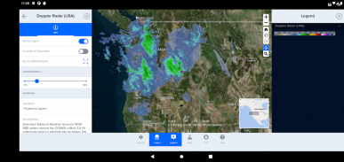
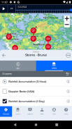
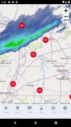
* ส่วนต่อประสานแผนที่แบบโต้ตอบแสดงอันตรายที่ใช้งานอยู่ 18 ประเภท
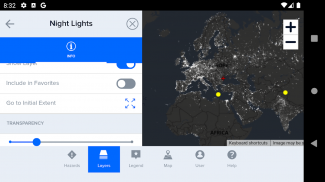
* แผนที่พื้นหลังที่ปรับแต่งได้
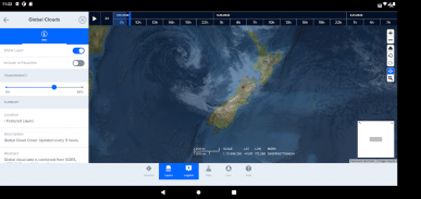
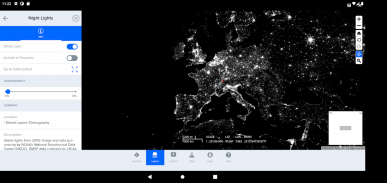
*แผนที่เลเยอร์ที่มีการซ้อนทับสำหรับความหนาแน่นของประชากร ความครอบคลุมของคลาวด์ทั่วโลก และอื่นๆ
Disaster Alert--เวอร์ชั่น521.755.201
(12-02-2025)
Disaster Alert - ข้อมูล APK
เวอร์ชั่น APK: 521.755.201แพ็คเกจ: disasterAlert.PDCเวอร์ชั่นล่าสุดของDisaster Alert
เวอร์ชั่นอื่น


 3.38
3.38

 4.34
4.34


แอปในประเภทเดียวกัน


